Simulating Severe Weather
By Louis J. Wicker
Dr. Dobb's Journal March 1999
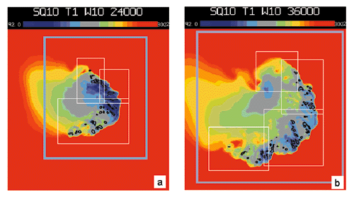
Figure 4: Plot of a simulated line of thunderstorms using an adaptive grid cloud model. The plotted domain is 400×300 kilometers. The color image depicts the surface temperature field, where red colors mean warm air and blue cold air. The black contours are the individual thunderstorms within the line. Overlaid rectangles are the adaptive grid meshes automatically placed by the driver/management module during the integration. The outer grid has a grid spacing of 18 kilometers, the blue-gray rectangle indicates the 6-kilometer grid mesh, and the inner white rectangles are the 2-kilometer meshes. (a) Simulation at 6.6 hours; (b) simulation at 10 hours.
Back to Article
Copyright © 1999, Dr. Dobb's Journal